Mayon volcano, one of the world's most active volcanoes, is currently erupting in the Philippines and a NASA satellite has captured breathtaking images of the event. According to Space.com, the Landsat 8 satellite recorded stunning views in early March, revealing bright red lava flows, ash clouds, and volcanic gases pouring from Mayon volcano's crater.
About Mayon Volcano: The Philippines' Most Active Peak
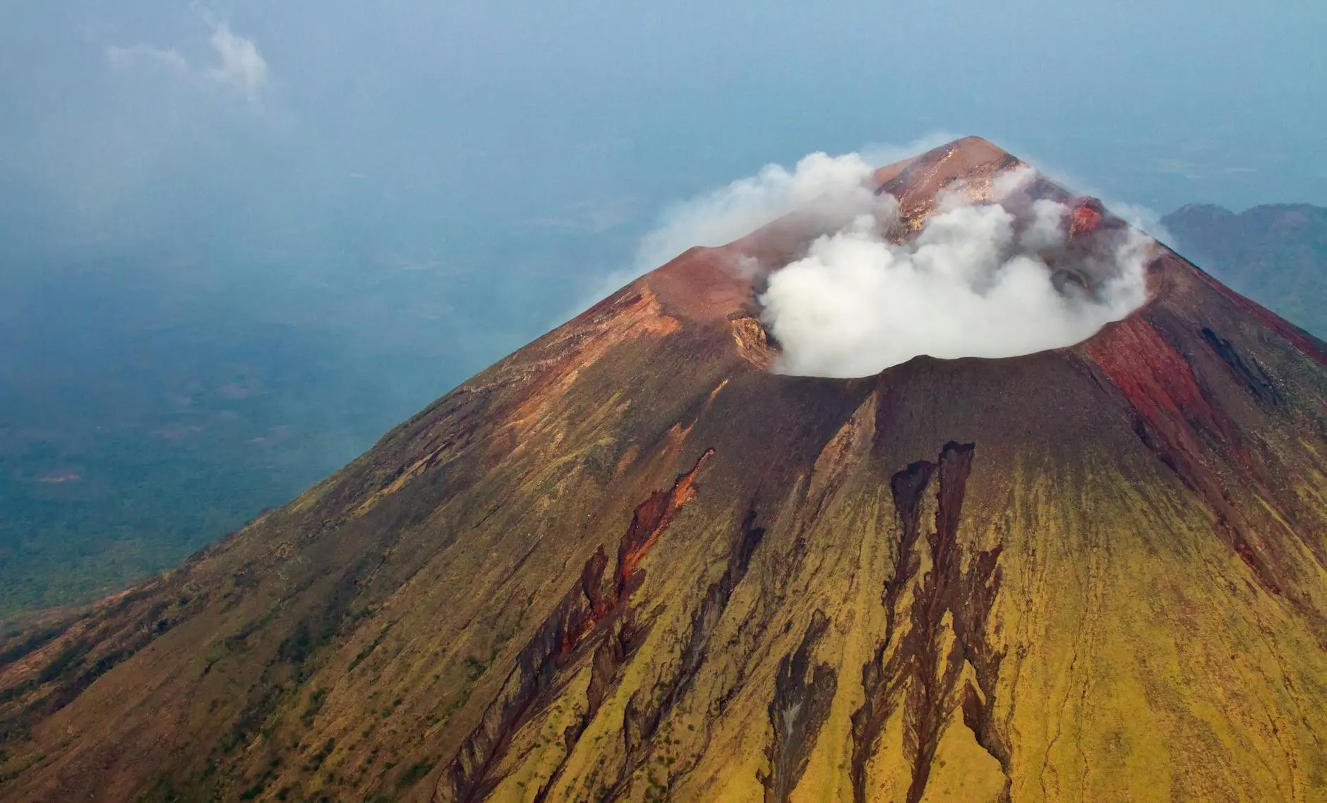
Mayon volcano is located in the Philippines' Albay province and holds the distinction of being the most active volcano in the country. Its nearly perfect cone shape has made it an iconic landmark and tourist attraction, but that same beauty masks serious volcanic danger for the hundreds of thousands of people living in its shadow.
The current eruption began in January 2026, when clouds of hot ash and lava flows started pouring from Mayon volcano's crater. According to NASA's Earth Observatory, the eruption has displaced hundreds of families from surrounding areas as authorities established danger zones to protect residents from potential hazards.
Mayon volcano has erupted nearly 50 times in the past 400 years, making it one of the most consistently active volcanic systems on Earth. These frequent eruptions have shaped both the physical landscape and the cultural relationship local communities have with the mountain they call home.
How Satellites Track Mayon Volcano Activity
The Landsat 8 satellite that captured these images of Mayon volcano is part of NASA's long-running Earth observation program, which has been monitoring planetary surface changes for over five decades. These satellites use sophisticated sensors to detect heat signatures, gas emissions, and surface deformations that indicate volcanic activity.
Space-based monitoring has revolutionized volcanology by providing consistent, wide-area coverage that would be impossible to achieve through ground-based observation alone. The thermal imaging capabilities of Landsat 8 can detect temperature changes on Mayon volcano's surface, helping scientists identify where lava is flowing and how the eruption is evolving.
According to NASA's Landsat program, these Earth-observing satellites have become essential tools for disaster monitoring, environmental research, and understanding how the planet is changing. The data they collect helps emergency responders, climate scientists, and urban planners make more informed decisions.
The Human Impact of Mayon Volcano's Eruption
While satellite images show the dramatic beauty of Mayon volcano's eruption, the human cost is significant for nearby communities. Local authorities have evacuated thousands of residents from designated danger zones as a precautionary measure. The displacement disrupts daily life, forcing families to stay in emergency shelters away from their homes and livelihoods.
Agricultural lands in the shadow of Mayon volcano are particularly vulnerable to ash fall and lava flows. The volcanic soil is normally fertile and productive, but during active eruptions, crops can be destroyed and farmland buried. For farming communities, Mayon volcano's activity represents both a long-term geological risk and an immediate economic disaster.
The Philippines' disaster management agencies have extensive experience responding to Mayon volcano's frequent activity, having developed evacuation protocols, early warning systems, and community education programs. This preparation saves lives, but cannot prevent the economic disruption and property damage that major eruptions cause.
Why Volcanic Monitoring Matters for Science
For those interested in environmental science and Earth systems, understanding Mayon volcano's activity provides important context about how the planet works. Volcanoes are natural laboratories that release gases, heat, and materials from deep within Earth, offering scientists clues about interior geological processes.
The technology used to monitor Mayon volcano—from space satellites to ground sensors—represents the cutting edge of Earth science. Careers in volcanology, natural hazard assessment, and disaster management rely on these monitoring systems to protect communities and advance scientific understanding.
Additionally, volcanic eruptions like those from Mayon volcano can have global climate effects when large amounts of sulfur dioxide reach the stratosphere. While the current eruption hasn't reached that scale, major volcanic events can temporarily cool global temperatures and affect weather patterns thousands of miles away from the eruption site.
The Future of Mayon Volcano and the Region
Volcanologists monitoring Mayon volcano will continue tracking seismic activity, gas emissions, and surface deformation to predict how the eruption might evolve. Some volcanic eruptions last only days or weeks, while others can continue for months or even years. The uncertainty keeps both scientists and local communities on alert.
Long-term, the region will likely recover as it has after previous eruptions of Mayon volcano. Volcanic ash eventually weathers into fertile soil, and communities rebuild. But the cycle will continue—Mayon volcano will erupt again, as it has for centuries, serving as a reminder that humanity shares this planet with powerful natural forces that operate on timescales far beyond human lifetimes.
The satellite images serve as both scientific data and a visual record of Earth's dynamic nature. From space, Mayon volcano's eruption looks almost artistic—a bright red stream of lava against the green landscape. From the ground, the story is more complex, involving natural wonder, human resilience, and the ongoing challenge of living alongside an active volcano that demands respect.
Comments 0
No comments yet. Be the first to share your thoughts!
Leave a comment
Share your thoughts. Your email will not be published.